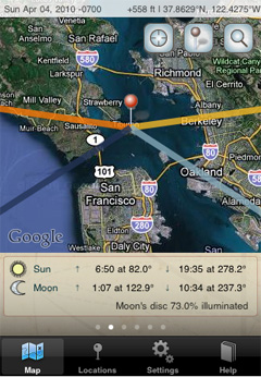
 I’ve written about The Photographer’s Ephemeris before: it’s a free desktop application that runs on Windows, Mac, and Linux.
It’s a tool that helps show you the exact position of the sun and moon on a particular time of day, overlaying their azimuths on top of a Google Map.
It’s hard to explain the entire program in one sentence because it does so much. But, it’s a tremendous tool for landscape photographers, because it can help you scout out areas and determine ahead of time if the sun will shine on a particular mountain peak at sunset.
Well, this great tool is now available for the iPhone too! Here’s a list of the app’s great features:
- Calculates sunrise/sunset times and azimuth for a particular day
- Calculates moonrise/moonset times and azimuth
- Overlays the sun/moon azimuth onto a Google map
- Easily change the time of day and watch sun/moon position change on the Google map
- Also calculates civil, nautical, and astronomical twilight times
- Quickly jump to any date in the past or future (useful for determining where the sun/moon will be during another season of the year)
- Save a list of frequent locations
- Calculate the elevation of the sun/moon at a particular time of day (helps you determine if the sun will be behind a mountain)
I’ve explored the iPhone app for about an hour already, and I think there’s only a few things I don’t like about it: (1) it doesn’t have the terrain maps and (2) no maps are available when you don’t have cell phone signal (often the case when you’re hiking in the mountains and remote desert).
I asked the developer, Stephen Trainor, about the terrain maps, and it turns out Google doesn’t support these maps on the iPhone yet. So, this really isn’t a bug or forgotten feature in the app… Google just needs to get their act together!
And, of course no maps are available when you don’t have cell phone signal. But, after thinking about this a little, I realized that this might not be a huge deal anyway. When I’m out on the trail, all I really want to know is where the sun/moon will be at a particular time. And, the app can still calculate these positions (azimuth/elevation) without signal. Then, I just use a compass to find the right azimuth, and approximate the elevation. Even if the maps were available while I’m out on the trail, I’m not sure I’d use them very often. For me, the maps are most useful when I’m at home scouting for locations 🙂
So, check out the free desktop application if you haven’t already, and if you want this great tool for your iPhone too, just search for it in the iTunes store or use the link on the Photographer’s Ephemeris website: http://photoephemeris.com/
If you enjoyed this article, and would like to read more, please signup for free updates by email or RSS.
 About the Author: Steve Berardi is a naturalist, photographer, computer scientist, and founder of PhotoNaturalist. You can usually find him hiking in the beautiful mountains and deserts of Southern California.
Cool! I have a copy on my MacBook, and am excited to try it out on my iPhone. Thanks for the update, Steve!
Steve,
You might want to ask the developer to look into open street maps. I know there’s some iPod apps that download and cache map tiles from that site. Perhaps those could be added to the application.
Oooh very nice
I simply could nott leave your web site before suggeseting that I extremely loved the
usual info a person provide for your guests?
Is going to be again regularly in order to inspect new posts